|
|
 |
 |
|
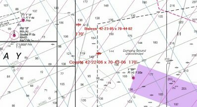
Wreck of the Coyote
The freight steamer Coyote (42-22-06 N x 70-43-06 W) was scuttled and abandoned off the Dumping Grounds, Outer Boston Harbor, in 1924. She is located in about 170 feet of water. Sources say she is mostly intact and upright. Note the Coyote is about 1.21 nm SE from the Baleen. Readings fluctuate between GPS and Loran units therefore you will have to use your depth sounder to aid in locating any wreck.
The links to the left provide current marine and local Massachusetts weather reports, extended local Massachusetts weather reports, tide charts (Boston, Massachusetts) and the US Coast Guard Navigation Center, featuring GPS information, DGPS sites (which are a must for anyone with a differential GPS), LORAN-C information, Local Notice to Mariners plus a boat load of miscellaneous navigational links and my Site Map. Although most of the links to the left provide local Massachusetts information, my out of state visitors can also find nationwide marine and weather information.
The links to the right have my Boating, Fishing, Knot Tying (fishing and boating knot tying instructions with pictures and some animations), Fish Filleting and Tackle Tips pages. My Saltwater Fish Species Page has color pictures of the most popular saltwater fish caught off the Massachusetts coast along with information such as their reproduction, habitat, food they eat, fishing season, saltwater angling tips, handling and cooking. Following those are my Search Engine pages, one with short descriptions and another in a table form, plus my Research Page. Last but not least, is my Doll House Gallery featuring the Farmhouse and The Garfield! These keep me busy in the winter.
This page is best viewed at a resolution of 800 x 600.
As you visit my pages you will notice I love animation. Feel free to copy any of the animations.
Please don't hesitate to contact me if you are having trouble locating marine, boating, saltwater fishing, tackle information or have any questions!
Email:
|
|
|
|
|
![line]() |
|
![line]() |
|